(click on 'refresh' to update data)
Based on BTTB Leaflet 7, 25 Sep. - 3 Oct. 1999, by
Jacques Peeters
and on documentation published by the NMBS, notably the
'Noord-Zuidkrant'
text translated 1999 by Alan REEKIE;
subsequent amendments are shown by: [ ] (last revised: December
2005)
Temperature in Antwerp at the time shown:![]()
(click on 'refresh' to update data)
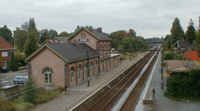
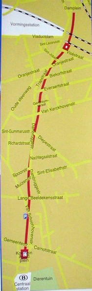
Starting point: Ekeren station, on SNCB/NMBS line 12 [and De Lijn bus route
73 ](for train schedules, consult: http://www.b-rail.be/ and for an interactive
map of the Belgian rail network: Network map
). [For local street maps showing cycle paths, see: Ekeren
Station, Merksem Jan
Palfijnziekenhuis and Luchtbal
Noorderdokken.]
[Note that for tariff purposes Ekeren station is within
the "Antwerp Agglomeration" but not the "Antwerp Zone"]
Length of walk: about
10 km
End point: Anwerp Central Station (shortcuts via bus or rail from some
intermediate points are indicated).
Note the beautiful station building, which is now owned and maintained by a local cultural association. Along the tracks to the north, you can see the bridge carrying the freight-only branch (L.27A) into Antwerp (right-bank) docks over the line to the Netherlands (L.12). [The track bed for the first part of a new route for freight traffic between the northern docks and L.16 just east of Lier (L.16A), has been added along the northern side of L.27A here. Track-laying on the first 4 km of it, to enable works trains to reach the HSL near Ekeren from the construction base in the Docks area without reversal, began in August 2004 and was in use by the beginning of 2005.]
Roughly half all rail freight traffic in Belgium runs to or from Antwerp
docks[ so during your walk you will probably see several freight trains on L.27A
(and possibly one of the trains for workers at Antwerp Noord yard and depot that
run in the rush hour, Mon-Fri, and were long unadvertised until they were opened
to the general public during major road reconstruction in 2004). As well as the
hourly Intercity trains between Brussels and Amsterdam, which are hauled (or
pushed) by dual-voltage electric locomotives in a distinctive bordeaux and
yellow livery, you may also see one of the Thalys TGVs that run each way five
times daily between Paris (Nord) and Amsterdam, on L.12].
[According to the Port of Antwerp : Railways
:
Antwerp is the terminus of 12 international railway routes, making it
Europe's leading railway port. Every day over 120 fully laden freight trains
leave the port, not to mention the 100 arrivals. In 2002 a total of 672,798
railway wagons passed through the Port of Antwerp, representing total goods
movements of 21.6 million tonnes. Since 15 Dec. 2002, several of those to and
from the Swiss border near Basel are hauled throughout by the same dual-voltage
locos (SNCB type 13 or CFL type 30), running via Namur and Athus. And since 12
Dec. 2004, Belgian type 12 dual-voltage locos and the SNCF's type (4)36000 locos
suitable for 1.5 kV, 3 kV DC and 25 kV 50Hz power have been sharing the task of
hauling through freight trains between Antwerp docks and railyards in northern
France.
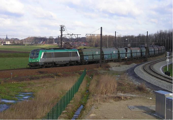
Above: On 25 January 2005, SNCF three-voltage loco 36060 was at the head of a block train of imported coal for France, passing the point in Ekeren where the temporary branch tracks giving independent access for HSL construction trains diverge from L27A.
The Eurailcargo quality services offer fixed times of departure and arrival :
- the Interdelta train to Southeast France,
- the Scaldo and Belalpia to
Austria,
- the Norlink to Scandinavia,
- the Carad to Southern Germany,
- the Belvetic to Switzerland,
- the Banana Express to Southern Germany
and
- a train to the Milan region.
The most rapidly-growing traffic consists of standard ISO containers, which can easily be transferred between rail and other transport modes. Apart from international services, B-Cargo operates scheduled domestic intermodal trains overnight between Antwerp docks (notably the Euroterminal and North Sea Terminal) and transhipment facilities in Belgium at Athus, Charleroi, Mouscron and Zeebrugge.]
Very much in the news at present are the plans for the reopening of the historic Iron Rhine route, which would give the Port of Antwerp a 50 km shorter link to the Ruhr Basin and Eastern Europe. An international study has concluded that the route could be reopened at short notice and would entail only limited capital expenditure. It seems likely that up to 15 trains a day will use the historic route [shortly after international agreement has been reached. A new locomotive workshed was opened at Antwerpen Noord in 2001, replacing that formerly at Antwerpen Dam; a new depot there followed later.]
A Web site to provide information on the EurailCargo trains and Belgian Railways' other freight services has been opened at http://www.bcargo.com/.
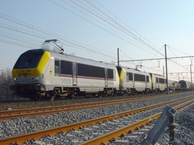
Above: International freight train hauled by a pair of CFL type 30 3/25
kV locos, on L.27A near Luchtbal
(photo taken 2003/02/22 © by Michel Van den Berghe). There's
another picture of this train at 10.
below.
Leave Ekeren station in the opposite direction, towards Antwerp, passing under the road over-bridge and then taking the first street on the left, the Kardelaan. At its end, take the footpath on the left. Note the rebuilt level-crossing keeper's cottage on the other side of the tracks. [Many such cottages, built to the same distinctive standard design, can be seen beside the siters of former level crossings all over Belgium]. Just before the footbridge and the sign: 'Privé-weg, domein NMBS', turn right and follow the footpath.
The footpath runs parallel to a stream along its left-hand side, and to the tracks of L.12, a bit further away. On the right are some old rubbish dumps.
The walk continues for about one and a half km through the nature reserve "Oude Landen". The rail tracks remains in sight on your left; the nearest are those of Line 12, and beyond them are sidings [used mainly to store peak-hour trains provided for people who work in or near the docks] and the signal-box B.8, built in 1970. Furthest away you can see Line 27A from the docks, on an embankment which falls to ground level as it gets closer to Line 12.
Behind it lies the embankment of the A12 motorway, alongside which runs the stream known as the 'Laarse Beek' which in September 1998, burst its banks and flooded the railway[, interrupting all through traffic for several days. The new high-speed line, (HSL4) north from Antwerp to Rotterdam, passes beneath the A12 motorway here and then runs north along the western side of the E19 motorway, passing the western outskirts of Breda, to a new bridge about 100m west of the existing one at Moersdijk, and thence runs almost directly to join the existing main line at Barendrecht].
The photo below, taken on 1st December 2005 during installation of the catenary at the transition between 3 kV DC and 25 kV 50 Hz power, shows the HSL near the 49.7 km post, looking west. Power will be supplied via a sub-station under construction on the right.
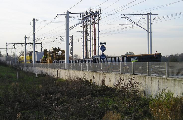
Both Line 12 and the line to the docks (L.27A) run side by side underneath a wide bridge[ carrying the A12 motorway. About 100 m to the east, a new underbridge has been provided for the high-speed line. The transition between 3 KV DC and 25 kV 50 Hz power will be located near the 49.7 km post, roughly where the future L.16A will cross the HSL ].
One day (perhaps in 2006) an second pair of tracks on an alternative route for traffic to and from Antwerp North Docks will diverge from L.27A about 1 km north of here and run via Merksem, Schoten and Wijnegem to join L.16 just east of Lier. For details of the route see URL: http://www.portofantwerp.be/asp/news_detail.asp?id=296
The BTTB is campaigning to ensure that suburban passenger services are operated on it too.
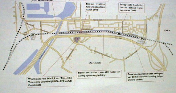
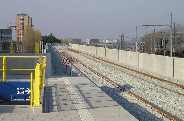
Keep on walking parallel to the tracks, passing under two more road bridges, until you come to the 'Noorderdokken' (Northern docks) halt which was almost closed a few years ago [it's indicated by the (B) at the right-hand side of the map below, but is in fact on the right of the adjacent road bridge (Havanastraat/Victor Govaerslaan)]. Take the passage under the tracks to reach the central platform, which is incidentally a good place for photography. The large parking area nearby was intended for use by buses providing connections with workplaces in the docks, but at first it was used only by a driving school... [However, in order to reduce the road congestion arising from the partial closure of Antwerp's ring motorway for resurfacing in the summer of 2004, such bus services are currently being provided. On the other hand, there are no nearby facilities for interchange with the new bus route 123, which was opened 23 August 2004 and now runs over the adjacent bridge on its way between Rooseveltplein and Merksem Keizerhoek via Luchtbal Montrealstraat.]
Return to the lane along the western side of the tracks[, then climb the stairs up to the Havanastraat/Victor Govaerslaan bridge and cross the busy road very carefully. Looking south-east from the bridge, you can already see the short new tunnel built to enable the high-speed line to pass underneath Line 27A (which has been diverted to run over it since early 2002) and the southbound track of L.12. (the photograph below was taken looking south from the Havanastraat bridge in April 2001. The class 51 diesel loco is heading north towards the docks on the normally southbound track of L.27A. Note the new colour-light signal bearing a white cross to show it was not then in use).
Return to the trackside lane and] keep on walking south until you reach the Argentinelaan. This road, which runs parallel with the tracks, had some good locations for taking photos before the bushes grew too tall.
[Until it closed permanently, on 15 March 2003,] we could spend a few moments
visiting the small halt at Luchtbal. Access to it remains almost hidden, on the
left in the corner at the end of Argentinelaan. [ It's The new
trackside embankment, provided here to reduce sound transmission, is] another
good place for photography. Near where its platforms stood,now
stand new trackwork allows trains to cross over in either direction
between the new line L.4/L.25 and L.12. And beyond the southern end of its
platforms, a viaduct carries the northern extension of L.25 over the northbound
track of L.12. Local cyclists are campaigning for the provision of a new cycle
track along the edge of the railway land here as far as Klipperstraat].
Afterwards, you should turn right into Manchesterlaan, and take the first street on your left, Columbiastraat. This densely inhabited district, which consists largely of blocks of flats built in the 1950s, took its name from the Café Luchtbal (whose owner had given it that name name to commemorate the hot-air balloon he saw fly past in 1905). Most of the streets are called after cities with ports, which is not surprising because Luchtbal is close to the docks. Past the football pitches you must turn right into the Tampicolaan, and then follow the footpath on the left of the angular modern church and on the right of the shopping centre.
Ahead of you lies the busy Noorderlaan, which you should cross at the traffic lights about 150 meters to the left. Formerly, metre-gauge Vicinal trams ran down its central reservation on their way via Ekeren to or from Zandvliet (until 1960), Lillo and Kapellen/Putte (until 1961) and Hoevenen/Kapellen (where the last tram ran on 2nd April 1966.
Although much of the line was on private reservation, with well-maintained tracks, well-equipped vehicles with plenty of room, the short-sighted management of that time decided to replace it with bus routes. Fortunately, extension of the urban tram network to Ekeren is now back on the agenda.
 This unusual name ('Full stop'), which is a wordplay on the
name of the operator of the urban and interurban transport network in Flanders:
De Lijn, has been adopted for Antwerp's new bus workshop and tram depôt, beside
the Noorderlaan. The building, formerly part of the General Motors' car assembly
plant, now houses the city's first low-floor trams built by Siemens. The trams
that run on lines 3, 8,11, 15 and part of line 12 are stabled here. The depot
will be extended with 4 tracks to accomodate more new trams. Unfortunately,
little of interest can be seen from outside.
This unusual name ('Full stop'), which is a wordplay on the
name of the operator of the urban and interurban transport network in Flanders:
De Lijn, has been adopted for Antwerp's new bus workshop and tram depôt, beside
the Noorderlaan. The building, formerly part of the General Motors' car assembly
plant, now houses the city's first low-floor trams built by Siemens. The trams
that run on lines 3, 8,11, 15 and part of line 12 are stabled here. The depot
will be extended with 4 tracks to accomodate more new trams. Unfortunately,
little of interest can be seen from outside.
Punt aan de Lijn is linked to the Antwerp tram network in Merksem (route 3) by a branch some 2 km long along the Groenendaallaan, which at present has no scheduled service. If you have already walked far enough, a bus on route 23 from Luchtbal, which runs along part of the central reservation towards Zuid, can take you back to the Central Station.
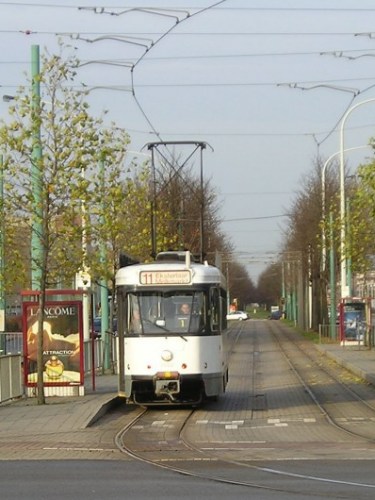
The photo (left) shows De Lijn tram 7102, which has just left Punt aan de Lijn depôt on its way to take up its duties on line 11, about to turn from Noorderlaan into Groenendaallaan (22 November 2003).
If you wish to continue the walk, follow the Noorderlaan south past the car-park of the Metropolis multi-screen cinema complex as far as the junction with Groenendaallaan. [Note the new terminal loop track around the car-park in front of the complex - which was installed in 2002, but has so far been left unused. The BTTB has recently proposed that it should become the northern terminus of a new tram route 18 running south to Eksterlaar via Astrid and Diamant.] Like the tram-tracks, we turn left here - but at the pedestrian crossing, of course.
We now pass the headquarters of the Linjebuss group, with a travel agency and hotel as well as the bus-garage. This company has become the biggest contract bus operator in Belgium by taking over De Polder, making it a major player in the context of the liberalisation of the public transport market. Originally independent, it is now a subsidiary of CGE.
Ahead lies the bridge carrying rail lines 12 and 27A, which has been widened to carry the tracks of the 'North-South connection' line [L.25 ]also. Partly through pressure from the BTTB, the six-platform interchange station known as Antwerpen Luchtbal has been built here, with the idea of forming a counterpart to Berchem on the southern approach to the city. The km-posts here reveal that the route via the new tunnel between Berchem and Dam stations is about 2.65 km shorter than that on the embankment via Antwerpen Oost.
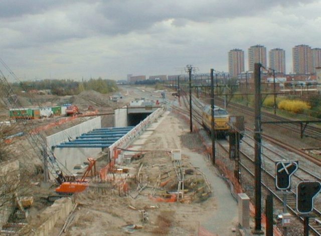
The photo below shows the double-track viaduct under construction to carry the northern extension of L.25 over the northbound track of L.12, which has been diverted to pass beneath it since October 2004. It was taken on 16 March 2005 from platform 1 of the new Antwerpen-Luchtbal station, in service as an unstaffed halt since 1 September 2003.]
Just before reaching the railway embankment, turn right into the
Klipperstraat and walk along it as far as the entrance to the Tjalkstraat
open-air bus garage, which dates from 1966. On the opposite side of the road,
the remains of a disused tunnel through the railway embankment [near the
high-voltage pylon could ] can be seen[ until the end of 2002].
This was originally built to enable Vicinal trams to reach the Ijskelder depôt
that was located here before the land was occupied by the motorway. Follow the
Tjalkstraat on the right until you reach the foot of the stairway back up to the
Noorderlaan. [Either climb up it now or first make a small detour by following
the footpath to the left at the foot of the stairs until you can turn right to
pass beneath the bridge carrying the Noorderlaan and reach the Straatsburgdok
Noorderkaai. The sign "Havenrecht" on the first building indicates it is where
boatmen pay the harbour dues; a similar bureau in Merksem Dock deals with
payments for use of the inland waterways. If you need a ship-chandlers's
services, the N.V. Nassau shop is on the quayside about 100 m further on;
otherwise retrace your steps to reach the foot of the above-mentioned stairway.]
At the top of the stairway, turn left along the pavement beside the Noorderlaan
as far as the centre of the bridge over the Albert Canal.
 From
here you get a good view over the bus-depôt and the rail track to Merksem beside
the canal. Until June 1967, the freight traffic on this line was hauled by SNCB
steam locomotives. [Erection of the new bowstring span to carry the North-South
junction line over the Albert Canal began on the future track-bed beside the
locomotives visible in the photo (left) in January 2003; it was rolled into
position in the late spring of 2004. It has a length of 115 metres and an air
draught of 9.09 m, compared with the 6.80 m of the existing spans, in order to
facilitate navigation. ]
From
here you get a good view over the bus-depôt and the rail track to Merksem beside
the canal. Until June 1967, the freight traffic on this line was hauled by SNCB
steam locomotives. [Erection of the new bowstring span to carry the North-South
junction line over the Albert Canal began on the future track-bed beside the
locomotives visible in the photo (left) in January 2003; it was rolled into
position in the late spring of 2004. It has a length of 115 metres and an air
draught of 9.09 m, compared with the 6.80 m of the existing spans, in order to
facilitate navigation. ]
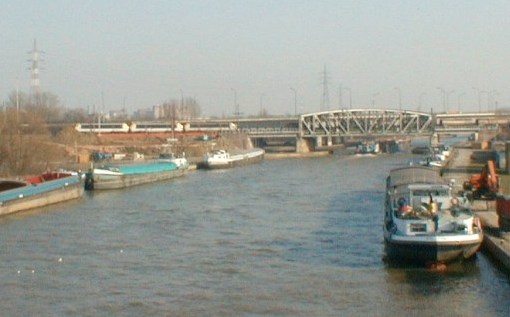
Continue walking south across the bridge and beyond until you reach the junction with the broad Ijzerlaan; turn left into it and continue as far as the first traffic lights. [As can be seen in square 72 in the extract from a map of the area published in the early 1920s, below,] the Ijzerlaan occupies the site of the initial length of the Campine Canal (Kempisch kanaal). [This canal now branches off the Albert Canal, which has long replaced part of the moat outside the former city walls.] The Vicinal trams to Kapellen etc. (see above) ran along its central reservation until the last line, to Schoten, was closed on 26 May 1966. [The additional pair of tracks for the North-South connection line is being laid along the west side of the NMBS property between the Albert Canal and the entrance to the new tunnel at Dam-plein; this required demolition of several old buildings including a disused factory chimney. The new bridge over the Ijzerlaan, another bowstring, and that over the Merksemsestraat, the deck of which is supported by a tubular arch, were installed in the spring of 2004. Track-laying here, followed by installation of signalling and the 3 kV catenary, was almost complete by the end of 2005.]
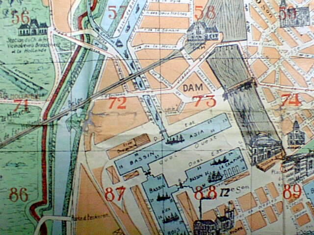
Map of the area surrounding Antwerpen Dam station (in square 58), circa 1922. Tram lines are shown in red. Note the sketch of the Vicinal tram station in square 56, on the lines to Brasschaat and Holland.
Turn right into Bredastraat at the first traffic lights in Ijzerlaan. Note that some of the brackets originally used to attach the span wires to support the wire supplying power for the Vicinal trams running down it towards the city centre can still be seen on the building at this corner. Keep left at the first fork in the road, and follow Viaduct Dam as far as the Damplein, at one side of which stands a distinctive building in Flemish Renaissance style.
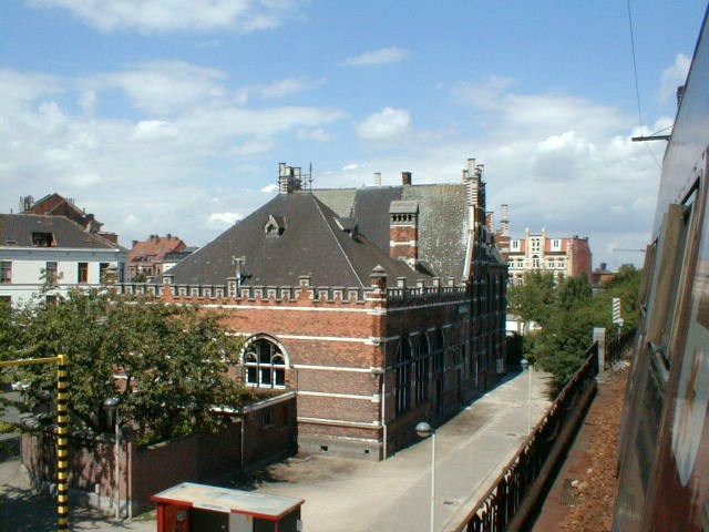
Above: The former Antwerp Dam station building, seen from a northbound train on the adjacent viaduct in August, 2000
[As is indicated by the words in Dutch and French cut into the stone on the side facing the entrance to Dam rail station on Line 12, ]this building contained the station offices before Dam became an unstaffed halt. It was originally erected some 36m away in 1892, but when the track level was raised in 1907 to enable the swing bridge over the nearby canal to be replaced by a fixed bridge, a plinth was installed beneath it so that could be raised 1m60 and moved en bloc to its present site. [Click here to see a picture taken while the move was in progress (one of Guy Demeulder's collection of Gares belges d'autrefois).The building is currently occupied by a restaurant and a social club for retired people.]
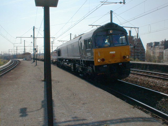
The photo above, taken at Antwerpen Dam on 3 April 2002, shows a 'Type 66' diesel loco in DLC Railway livery leased from the Porterbrook company hauling the first scheduled private rail freight service in Belgium, which is being operated by the Dillen et Le Jeune Cargo (DLC) company to convey containers for the BMW motor company between Antwerp Baerendrecht and Wackersdorf (Bavaria) via Montzen and Nuremburg.]
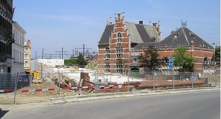
Today, it stands beside the final section of the tunnel enclosing the new rail line beneath central Antwerp [from just north of Berchem, in fact, although only the part north of Centraal station is shown in the map in section 13. below,] which will eliminate the need for all through trains via Central Station to reverse there. [Since 1873, the present roundabout route via Antwerpen Oost has replaced the original direct line which was opened in 1854 and ran where Van Schoonhofstraat, Rotterdamstraat, Hollandstraat and Trapstraat now stand. The location of the new tracks in this area is determined by the need for them to climb up to the level of the existing tracks where they cross the Ijzerlaan. Therefore the line crosses the Damplein in a reinforced concrete tunnel which rises at a slope of about 27 in 1000. The roof of this tunnel is above ground level in the northern half of the Damplein, (as can be seen in the photo below, taken in June 2004). ]
[Until the autumn of 2001,] the NMBS/SNCB's Dam workshops
[were]are located alongside the embankment southeast of
Antwerpen Dam station, as you can see by walking a bit further south along the
Viaduct Dam until you stand on the bridge where it [formerly] crossed the tracks
into Dam diesel loco shed on the west. All [Most of] this
semi-derelict land will soon become is available for reuse, as
both the loco shed and railway workshops will shortly be[have
been] closed, and replaced by modern versions on new sites close to the main
marshalling yard within the docklands, to make way for the new direct through
line here. [Preparations for casting the reinforced concrete roof of the new
tunnel between its deep reinforced concrete walls (cast in situ using the usual
'diatomite mud replacement' method) can be seen in the photo (below), which was
taken on 3rd April 2002, looking north from the 'Viaduct Dam' road bridge
towards the former station building (behind the red panel). The nearer tunnel
wall cuts into its northern abutment behind the wooden fence.]
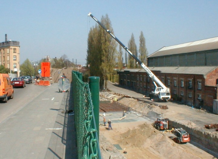
Since 20 January 2003, the contractor Besix has been working on the new infrastructure between Antwerp Damplein and the Albert canal. This involves, in particular, construction of a cut-and-cover tunnel containing the inclined plane leading from the tunnel bored under Viséstraat up to the rail level on the existing viaduct, and manufacturing and supplying the metal bridges to carry the railway over the Ijzerlaan, Merksemsestraat and the Albert Canal, including a sound-absorbent wall between Merksemsestraat and the Albert Canal. Construction of the tunnel across the Damplein has been split into two stages so that local road traffic can flow without interruption. During the first stage, from January to October 2003, traffic was diverted around the northern side of the Plein, to Hardenvoort. In the second stage, since the end of 2003, access has been restored to the Viaduct Dam and the northern diversion closed. Finally, the area around the Damplein is being given a new layout, devised by the winner of the "Spoor Noord" competition.]
[Until all passenger trains are re-routed via this 'North-South connection', probably at the end of 2006,] you can conclude your tour here, by walking back to Antwerpen Dam halt and taking a train from platform 2 to Berchem (departures at 12 minutes past every hour on weekdays). [Looking right from this train you can see, immediately after passing the two distinctive water-towers and over the bridge beside the Schijnpoort stopping-place for buses (route 23), trams (line 12 to Wim Sarensplein) and the pre-metro (route 3 between Merksem Keizershoek and Zwijndrecht, in tunnel beween of Sportpaleis and F. van Eedenplein since 1 April 1996), the fan of new stabling sidings for passenger trains, which has been created to replace various older ones, notably along the approach to Centraal station. On the left-hand side, here, the Schijnpoort multimodal freight terminal can easily be recognised from its stacks of ISO containers.]
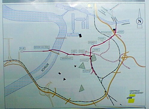
Sketch map showing the existing rail lines (black), pre-metro tunnels (red) and motorways (yellow) in the Antwerp area. Central station is situated beside the intersection of the three pre-metro lines; Dam station is situated where the black line running down from the top of the map starts to curve east, roughly level with the southern edge of the two dock basins nearby. The pre-metro tunnels shown in pink have been excavated, but only the short spur east from Schijnpoort has so far fitted out for operational use.
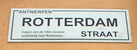
Otherwise, you can complete your walk back to the centre by following [either]the route finally taken by the Vicinal trams to reach their terminus in Rooseveldtplaats[, or that of the original direct railway of 1854]. The trams continued along the Viaduct Dam beside the sidings to the west of the loco-shed as far as Ellermanstraat. [These sidings, now removed, terminated in the still-standing Antwerp North goods station, which was built in 1873 as the main transhipment point for less-than-waggonload traffic to and from the docks but now has only road access.] Then the Vicinal lines turned left along the Lange Dijkstraat as far as St-Jansplein [where, before the extension to Rooseveldtplaats was opened, some of them terminated and where the others turned right towards their then terminus in Paardenstraat], and continued via Van Maerlantstraat and Osystraat to the Rooseveltplaats. [Alternatively, follow the route of the former direct rail line, which is slightly to the west of the new tunnel shown on the plan. Start by walking down the steps into Trapstraat and along it, then along Dambrugge as far as Sint-Gummariusstraat. Turn right into it, then take the first street on the left: Hollandstraat, which follows the route of the former railway. This leads into Rotterdamstraat, which has recently been given distinctive new name-plates pointing this out (see photo below), and follow the tram-lines along it and Van Schoonhofstraat until you reach Central Station.]
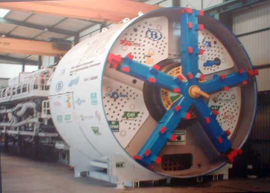
 The twin
tunnels, each 8.4 metres in external diameter as shown below, have been
excavated by a rotary boring machine which began its work in a pit beside
Viaduct Dam, about 100 m north of Viséstraat, in October 2002. North of this
point, which is about 1190 metres from Central Station, the remaining 360 metres
of the tunnel to its portal at the Damplein were built using the 'cut and cover'
technique with a gradient of about 27 in 1000.
The twin
tunnels, each 8.4 metres in external diameter as shown below, have been
excavated by a rotary boring machine which began its work in a pit beside
Viaduct Dam, about 100 m north of Viséstraat, in October 2002. North of this
point, which is about 1190 metres from Central Station, the remaining 360 metres
of the tunnel to its portal at the Damplein were built using the 'cut and cover'
technique with a gradient of about 27 in 1000.
The boring machine (see photo below) first headed south parallel to
Trapstraat and then it ran beneath Dambruggestraat as far as Spoorstraat.
Finally, it passed beneath the multistorey car park off Van Schoonhovenstraat,
the Astrid Park Plaza Hotel and the metro station at Astrid Square, to reach the
pit about 24 metres (at rail level) beneath street level that has been excavated
in front of Central Station.
After completing the first bore in February
2003, the machine was dismantled in preparation for rebuilding at the pit beside
Viaduct Dam to be used in excavating the second bore.
The first trains are due to run through the new tunnels in December 2006.
An Information Centre on the "North-South connection" is located inside
Central Station at 27 Astridplein, open:
Tuesday and Wednesday: 10h - 12h30;
13h30 - 17h
Thursday: 13h - 17h and Friday: 10h - 13h.
See also (in
French): "La
jonction nord-sud d'Anvers" and
"La
ligne à grande vitesse Anvers-frontière néerlandaise - travaux à
mi-parcours"
The BTTB Bond van Trein-, Tram en Busgebruikers is at H. Frère-Orbanlaan 570 9000 Gent Tel. +32 - 9 - 223 86 12 Fax +32 - 9 - 233 97 29 E-mail: bttb@skynet.be
For news about transport developments in Antwerp (mainly in Dutch, but with
some pages in English), see the Web site:
http://www.werkenantwerpen.be/
Please send any comments or suggestions regarding this
page by e-mail to : ![]()